Hakkari is one of Türkiye’s most dramatic mountain destinations, but it is not a casual turn-up-and-walk hiking stop. The Cilo–Sat Mountains National Park, high-altitude lakes and long road approaches reward careful planning, flexible timing and local knowledge. This guide focuses on what can be planned responsibly without promising access, weather or activities that can change at short notice.
Why visit Hakkari?
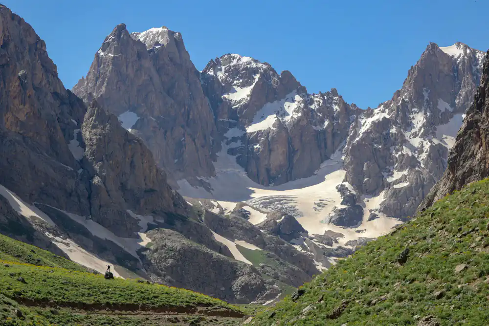
Hakkari suits travellers who value high-mountain scenery, quiet landscapes and a slower journey more than a checklist of famous monuments. Türkiye’s official tourism portal describes the province as overwhelmingly mountainous and highlights the Cilo Mountains, Sat Lakes, Cennet–Cehennem Valley and Barçelan Highland. The scenery is the reason to come; the logistics are part of the experience.
This is also a destination where human expertise matters. Remote roads, sudden weather changes and locally controlled access make a knowledgeable local driver or mountain guide more useful than an overfilled self-guided itinerary. That practical, flexible style also reflects the current shift toward restorative nature travel and trusted local guidance.
Cilo–Sat Mountains National Park and the Sat Lakes
The Sat Lakes lie in the high country of Cilo–Sat Mountains National Park. The official GoTürkiye destination page describes glacial lakes above 3,000 metres in the wider mountain area. Conditions at that elevation can differ sharply from Hakkari city or Yüksekova, even on the same day.
Access is seasonal and conditional
Do not treat a map pin as confirmation that a road, trail or recreation area is open. Snow, rain, road works, conservation measures or local security controls can affect access. Before departure, confirm the route with your accommodation, licensed local guide and the relevant local authorities. For remote mountain days, travel in daylight and share the day plan with someone not in your vehicle.
What to pack for a mountain day
- Sturdy footwear with grip; the ground can be wet, rocky or uneven.
- Warm layers and a waterproof outer shell, even in summer.
- Sun protection, water and food; services are limited away from settlements.
- An offline map and charged power bank, while remembering that a phone is not a substitute for a guide.
- A personal first-aid kit and any essential medication.
High altitude affects people differently. Keep the first day gentle, drink water and turn back if weather or health makes the plan doubtful. Swimming, climbing, camping and drone use may be restricted in protected or sensitive areas; check locally rather than assuming they are permitted.
Other nature stops to discuss with a local planner
Barçelan Highland
Barçelan is promoted by the official destination authority for its highland landscape and clean air. It can be a calmer alternative to a demanding trek, but it still requires a condition check and suitable transport.
Cennet–Cehennem Valley
The valley is known for steep mountain scenery and is another place where route knowledge matters. Ask what viewpoint or walking section is realistic for the day instead of committing to an unverified trail name or distance.
Kaval Waterfall and shorter nature stops
Kaval Waterfall appears on the official Hakkari destination portal as a nature stop. Shorter outings can be valuable when cloud, fatigue or road conditions make a high-altitude plan unwise. A good Hakkari itinerary always needs a lower-risk alternative.
Choose a Hakkari plan that can change safely
| Conditions and experience | Suitable priority | Confirm before departure | Fallback |
|---|---|---|---|
| First visit or limited mountain experience | City orientation and a locally selected lower-altitude outing | Driver, walking surface, daylight and return | Meydan Madrasa and a short viewpoint |
| Good forecast with experienced local support | One confirmed Cilo–Sat objective | Access, guide, supplies and turnaround time | Barçelan or another accessible lower route |
| Cloud, rain, snow or uncertain access | Culture, food and a conservative local drive | Road status and indoor opening arrangements | Keep the mountain day uncommitted |
| Winter journey | A road-based itinerary designed for current conditions | Flight, vehicle, equipment and weather advisories | Additional night or postponed mountain travel |
Five checks before a remote mountain day
- Identify one objective. Write down the exact valley, lake area or viewpoint agreed with the local guide instead of combining several map pins.
- Confirm access on the day. Ask whether the road and intended walking section are currently open and appropriate for the group.
- Agree the limits. Record the start point, walking level, turnaround time, vehicle return point and the condition that will cancel the outing.
- Prepare for self-sufficiency. Carry the agreed clothing, water, food, medication, offline navigation and charged communications equipment.
- Leave the plan with someone. Share the vehicle, route, group details and expected return, then report back after the outing.
Use a clear go-or-switch decision
- Proceed only when the guide, road access and weather all support the same plan.
- Switch to the lower-altitude alternative when any one of those checks is uncertain.
- Return or postpone when conditions deteriorate, a participant feels unwell or the agreed turnaround time is reached.
A successful Hakkari day is one that returns within the agreed limits. Reaching a lake or summit is optional; overriding current local advice is not.
A realistic two-day Hakkari outline
Day 1: arrive, orient and keep the plan light
Use the first day for the city, local food and a short outing selected after checking conditions. Hakkari’s Meydan Madrasa is the main historic landmark named by the official tourism portal. Leaving space in the schedule helps if a flight or road transfer runs late.
Day 2: one major mountain objective
Choose one focus—such as the Sat Lakes area or another accessible valley—rather than trying to combine several remote sites. Start early with a local guide or driver, carry supplies and agree on a turnaround time. If access is not confirmed, switch to a lower-altitude viewpoint or cultural stop.
Example brief to send a local guide
“We are two adults arriving in Yüksekova on [date]. Our priority is mountain scenery rather than a summit. We can walk for [time] on uneven ground, have [relevant experience or mobility needs], and need pickup and return to [base]. Please propose one currently accessible route, a lower-altitude alternative, the required clothing and supplies, and the latest safe turnaround time.”
Replace the brackets with real details. Do not ask a provider to confirm a generic “Cilo tour” without identifying the intended route, vehicle access and walking level.
Questions that need a dated answer
- Which exact start and finish points are proposed, and how much of the day is driving?
- Who has checked today’s road, trail, weather and local access conditions?
- What elevation, terrain and walking duration should the group expect?
- What equipment and food must each traveller bring?
- What is the alternative if the primary route is unavailable?
- Who makes the final safety decision, and how is a cancellation or route change handled?
Departure-morning checklist
- Reconfirm the route and weather with the guide.
- Check every participant’s clothing, water, food and medication.
- Save the driver and accommodation contacts offline.
- Share the expected return time with a named contact.
- Leave immediately if the guide advises an earlier start; otherwise shorten the objective instead of extending the return into darkness.
Getting there and getting around
Yüksekova Selahaddin Eyyubi Airport is the nearest air gateway for many itineraries, but routes and operating days can change. Check the airline and airport timetable for your exact date before arranging onward transport. Intercity road travel is possible, although mountain weather can lengthen journeys.
Public transport is not designed around trailheads. For mountain areas, a private vehicle with a driver who knows the current route is normally more practical. Travellers combining Hakkari with Van can read our Van and Lake Van guide and the broader Eastern Turkey guide.
Example sequence for a confirmed mountain day
The evening before: meet or call the guide, review the intended route on a map, agree the vehicle pickup, and move food, water and layers into day packs. Set the alternative route at the same time.
Before departure: repeat the weather and access check. If the guide cannot confirm the primary objective, switch immediately; do not drive toward a closed or uncertain route in the hope that conditions improve.
On arrival: identify the return vehicle point and the turnaround time before walking. Start gently and keep the group together. The traveller with the slowest comfortable pace sets the schedule.
At the decision point: continue only when the whole group is well, visibility is adequate and the return remains within daylight. Otherwise, pause for the view and turn back.
After returning: notify the person holding the day plan, check the next day’s road or flight information, and leave wet equipment where it can dry. Do not add another remote stop simply because the group returned early.
Where to stay and who this trip suits
Hakkari city and Yüksekova are the most practical bases for services. Choose a base according to the next day’s confirmed route, not only the lowest room price. Ask about early breakfast, driver coordination and late arrival procedures before booking.
This trip best suits experienced independent travellers, photographers and small private groups comfortable with long road days and changing plans. It is less suitable for travellers expecting barrier-free access, guaranteed daily departures or a resort-style holiday. Families should discuss walking surfaces, drive times and child-safety needs in advance.
Responsible travel in Hakkari
- Use established access routes and follow national-park guidance.
- Take all waste back to town and avoid disturbing livestock or wildlife.
- Ask before photographing people, homes or working villages.
- Support local restaurants, guides and accommodation providers.
- Never pressure a driver or guide to continue when weather or access is unsafe.
Plan a private Hakkari journey
Travel Agency Turkiye can help coordinate a custom route without inventing guaranteed mountain access. Share your dates, walking ability, preferred pace and arrival point through Plan My Trip. Agencies and private groups can also review our Türkiye DMC services. Any operational proposal should be confirmed for the actual travel date.
Hakkari travel FAQs
When is the best time to visit Hakkari?
Warmer months generally offer the best chance of reaching high country, but snowmelt, storms and road conditions vary. Confirm access shortly before travel rather than relying on a fixed calendar window.
Can I visit the Sat Lakes without a guide?
A local guide or driver is strongly recommended because the area is remote and access conditions can change. Do not rely only on online route traces.
Is Hakkari a good winter destination?
The snowy landscapes are striking, but winter makes many mountain routes more difficult or inaccessible. A winter trip needs a conservative road plan and date-specific local confirmation.
How many days do I need?
Allow at least two full days after arrival, with one flexible weather day if the mountain scenery is your priority. Combining Hakkari with Van or another eastern city requires additional travel time.
Fact check: official GoTürkiye Hakkari destination information reviewed 8 October 2026. Access, weather, flight schedules and local permissions must be reconfirmed for the traveller’s exact dates.