

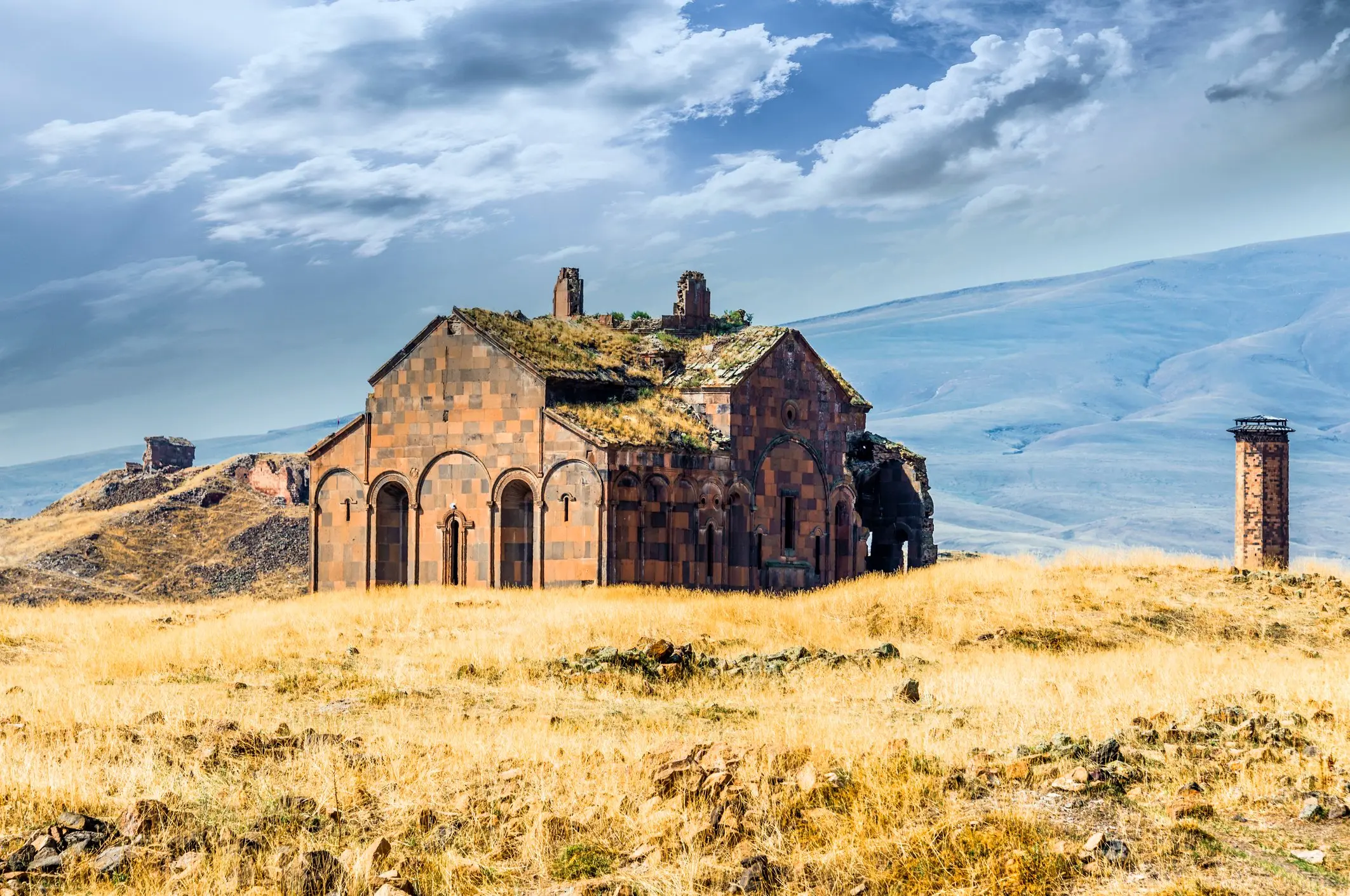

Ani is not a single ruin to tick off on the way out of Kars. Its cathedral, churches, mosque and walls stand across an exposed plateau above the Arpaçay valley, with enough distance between them to make walking conditions part of the experience. This Ani archaeological site guide is designed for travellers who want to understand the monuments and plan a sensible visit rather than simply collect a panoramic photograph.
For the city base, regional food and a wider itinerary, use our Kars and Ani travel guide. Here the focus stays on the site itself.
Why Ani is a UNESCO World Heritage Site
Ani became a capital of the Armenian Bagratid kingdom and an important medieval trading city. Its location brought commerce, political competition and architectural exchange. Later Byzantine, Seljuk and Georgian periods added to its history; it should not be reduced either to one dynasty or to a vague “Silk Road city” label.
UNESCO inscribed the Archaeological Site of Ani on the World Heritage List in 2016. The surviving religious, residential and defensive remains demonstrate the city’s cultural layers and architectural achievements. Trade-route changes, conflict and the effects of an earthquake in 1319 form part of its long decline, rather than one neat story of a city suddenly disappearing.
Many buildings are fragile or partially ruined. Conservation, restricted access and empty spaces are part of visiting an archaeological landscape, not evidence that every doorway is safe to enter.
The monuments worth slowing down for
Ani Cathedral
Construction began in 990 and was completed in 1001, according to the Kars Provincial Directorate’s account. Its surviving form rewards attention to proportion, masonry and the engineering of a major Armenian church. Read the interpretation before trying to reconstruct the missing roof in your imagination.
Do not enter a restricted area or stand beneath unstable-looking fabric for a photograph. Access arrangements can change during conservation; the exterior remains important even when an interior route is unavailable.
The Church of St Gregory of Tigran Honents
This church dates to 1215. The name matters because Ani has more than one church associated with St Gregory, and their histories should not be merged. Where access permits, look for the relationship between exterior carving and surviving painted decoration. Do not assume that a photograph of a fresco guarantees interior access on your visiting day.
Manuçehr Mosque and the valley setting
The mosque is another essential part of Ani’s layered religious landscape. Its position helps explain how architecture and terrain work together across the city. Use designated viewpoints to appreciate the valley; an attractive edge in a photograph is not an invitation to leave the visitor route.
Walls, gates and the spaces between buildings
The fortifications provide a sense of the city’s ambition, but the empty ground is worth noticing too. Ani was a living urban place, not a scattered collection of freestanding churches. A guide can help connect visible remains with streets, neighbourhoods and the wider trading landscape without presenting every uncertain reconstruction as fact.
A practical two- to three-hour walking plan
Allow about two to three hours inside the site as an initial planning estimate, longer for detailed interpretation or photography. The drive from Kars and any waiting or admission time are additional. A short visit may need a smaller selection of monuments, not a faster walking pace over rough ground.
- Begin at the entrance and walls. Read the current site map, note closed sections and ask where the permitted route runs that day.
- Continue towards the cathedral. Use it as an introduction to the scale and architecture of medieval Ani.
- Add the mosque and an authorised valley viewpoint. Keep away from unstable edges and conservation areas.
- Include Tigran Honents if the open route and your walking ability allow. Leave enough energy and daylight for the return to the exit.
This is a selection of stops, not a guarantee of a continuous accessible circuit. Follow current signage over a saved route on your phone. Some monuments may be closed or require detours, and the exposed landscape can make distances feel longer than a map suggests.
Getting there from Kars—and getting back
Ani lies around 40 kilometres east of Kars, near the Armenian border. Arrange both legs of the journey before leaving the city. A prearranged vehicle can suit travellers who want control over visiting time; anyone using a local excursion or public transport should verify its actual operating day, departure point and return arrangement.
Do not rely on an old blog timetable or assume a taxi will be waiting at the site. Confirm waiting time, pickup location and the price basis directly with the provider. This guide does not quote a fare, advertise a fixed shuttle or promise same-day availability.
The river valley is an international boundary, not a sightseeing crossing. Remain in permitted areas. Ruined historic bridge remains do not provide a visitor route into Armenia.
Best season, weather and walking conditions
Spring and autumn can appeal to travellers who prefer cultural visits outside peak summer, but conditions vary sharply at this altitude. Spring paths may be muddy; autumn can bring cold weather or early snow. Summer visits require water and sun protection because shade is limited. Winter can be visually striking but involves serious cold, shorter daylight and possible road or path disruption.
Choose grippy footwear, carry an extra layer and check the forecast and road situation shortly before departure. Avoid making a winter photograph the basis of a fixed transport commitment. If conditions deteriorate, reducing or postponing the walk is more sensible than pressing on to every monument.
Families, mobility and respectful visiting
Families can make Ani manageable by choosing a few buildings and telling a clear story about the people who lived here. Keep children close near drops, broken masonry and uneven ground. Stones are archaeological material, not souvenirs or climbing equipment.
Travellers with limited mobility should request current details about entrance access, surfaces, gradients and the specific monuments reachable on a shorter route. “Open-air” does not mean paved or step-free. Ask about toilets and other facilities before departure rather than assuming they are available beside every stop.
For a more satisfying day, return to Kars for a meal and time to reflect instead of adding another long drive. Our Eastern Anatolian food guide offers context for the region’s food traditions; individual restaurants and tastings still need their own checks.
Build Ani into a wider Türkiye journey
Browse our Eastern Türkiye guide and Türkiye tour options for regional context. Use Plan My Trip to request a realistic Kars stay with a site visit matched to your walking ability and season. Travel professionals can contact our Türkiye DMC services team for group planning; transport, guiding, admissions and special access are confirmed separately, not promised by this article.
Ani visitor FAQs
How much time should I allow at Ani?
Two to three hours can suit a selected monument walk in suitable conditions. Add the return journey from Kars and more time if you want in-depth interpretation.
Is Ani an Armenian heritage site?
Yes. Its role as an Armenian Bagratid capital and its Armenian churches are central to its history. Other communities and later rulers also shaped the city.
Can I visit every building inside?
Not necessarily. Structural conservation, closures and the current visitor route determine access. Check on arrival and respect barriers.
Can I cross the border from Ani?
No visitor border crossing is provided through the archaeological site. Stay within the authorised site route.
Sources and planning checks
Reviewed 15 October 2026: UNESCO’s Archaeological Site of Ani record (World Heritage inscription 2016), Kars Provincial Directorate monument histories, and the official Ani museum listing. Reconfirm admissions, open routes, weather, roads and return transport for your dates.
0 Comment